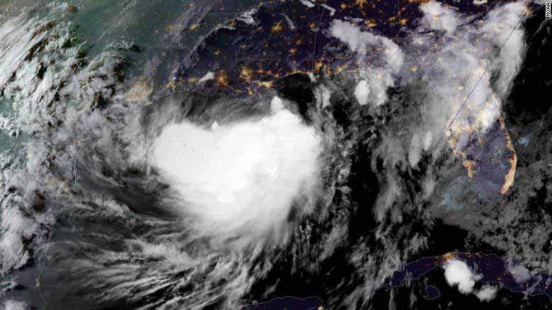
Tropical Storm Barry will make landfall this Saturday morning on the Louisiana coast near Morgan City as a category one hurricane, according to the latest Meteorological Service forecasts.
The authorities have alerted the population of the extraordinary danger posed by the storm, whose slow advance and density could drop more than 20 inches of rain, as well as a powerful storm surge and a river that already threatens to overflow. It is expected that the strong winds and rains could affect at least 3 million people.
The governor, John Bel Edwards, has highlighted the danger facing residents, calling it a triple threat.
“This is going to be a major rain event in a lot of Louisiana,” said Edwards, who authorized the deployment of 3,000 members of the National Guard. “There are three ways in which Louisiana floods: storm surge, high rivers and rain, and we’re going to have all three.”
President Donald Trump declared a federal emergency for Louisiana on Thursday night, ordering government assistance to the state and local emergency response efforts. It is expected that Barry may also affect some areas of Mississippi. The governor decided to extend the declaration of state of emergency also there.
It is anticipated that Barry’s slow movement over the warm gulf will increase the power of the storm to at least one Category 1 hurricane designation, according to the update of the National Hurricane Center on Friday afternoon.
Around ten o’clock on Friday night, Barry was on Friday about 75 miles (120 kilometers) south of Morgan City, with winds of 65 miles per hour (100 kilometers per hour).
On Isla Grande, there was no electricity on Friday night. The town, which had been evacuated previously, was already suffering a partial flood.
The authorities told some 10,000 residents from areas particularly exposed to the Barry Pass to evacuate. However, it was not planned to adopt this measure in New Orleans.
The city issued a shelter order that went into effect this Friday at 8:00 p.m., local time, for residents to take their shelter and not go out to the streets or to their work centers or schools.
Flood gates were closed throughout the city in anticipation of flooding that endangers people’s lives along the central Gulf Coast and Lower Mississippi Valley.
Among other recommendations, local authorities have asked New Orleans residents to have at least three days of supplies on hand and to keep the storm drains of their neighborhood clear so the water can move quickly.
The weather service also calculates that the water will not exceed the levees, which have not been exceeded in New Orleans since the 1920s. But authorities have warned that a change in the intensity or direction of the storm could affect that calculation.
Late on Friday night, residents received good news: the Mississippi River is expected to grow in New Orleans at about 17.1 feet (5.2 meters), not at 19 feet (5.8 meters) as previously predicted. The levees that protect the city vary from about 20 to 25 feet (6 to 7.5 meters) in height.
To prepare for the eventual flooding, crews are reinforcing the levees in at least two areas, Boyett said. They set up metal barriers at Harvey Lock, a part of the levee near the Lower 9th Ward, the neighborhood destroyed during Katrina.
“Workers trust the integrity of the levees,” Boyett said. “It’s a material designed to withstand this kind of pressure.”

